🌿 Weather Forecast for the Next Field School 2025 Stops in Costa Rica 🌍
The Field School, organized by Foreste per Sempre OdV and UNIMORE, continues its journey in Costa Rica, with upcoming stops at Volcán Tenorio (February 4-7) and Tortuguero (February 8-10). Below is the expected weather forecast for these areas, along with a look at Montezuma and the Karen Mogensen Reserve.
General Weather Conditions
The Intertropical Convergence Zone (ITCZ) has shifted southwards to Panama, keeping dry conditions over most of Costa Rica. However, within the next 72 hours, a segment of the ITCZ might approach western Nicoya Peninsula from the Pacific, though it is unlikely to cause significant rainfall.
The atmosphere will remain relatively dry between 700 and 300 hPa, limiting convective cloud development in most regions. However, mountainous areas, such as Volcán Tenorio, will experience increased cloud cover.
Trade winds will strengthen, reaching speeds of 20-60 km/h, particularly in the Caribbean, Northern Zone, Central Valley, and Northern Pacific. Additionally, the Papagayo Jet will be activated, a strong wind generated by the pressure difference between the Caribbean Sea and the Pacific Ocean. This wind significantly impacts marine biodiversity, enhancing upwelling, which brings nutrient-rich deep waters to the surface, supporting a rich marine ecosystem.
Weather Forecast for the Field School Stops
Volcán Tenorio (February 4-7)
🌡️ Temperatures: Lows 18-19°C, highs 22-24°C
💨 Winds: Gusts up to 100 km/h in exposed areas
☁️ Sky: Partly cloudy, with denser clouds along the slopes
🌧️ Precipitation: Light showers possible on February 6
Tortuguero (February 8-10)
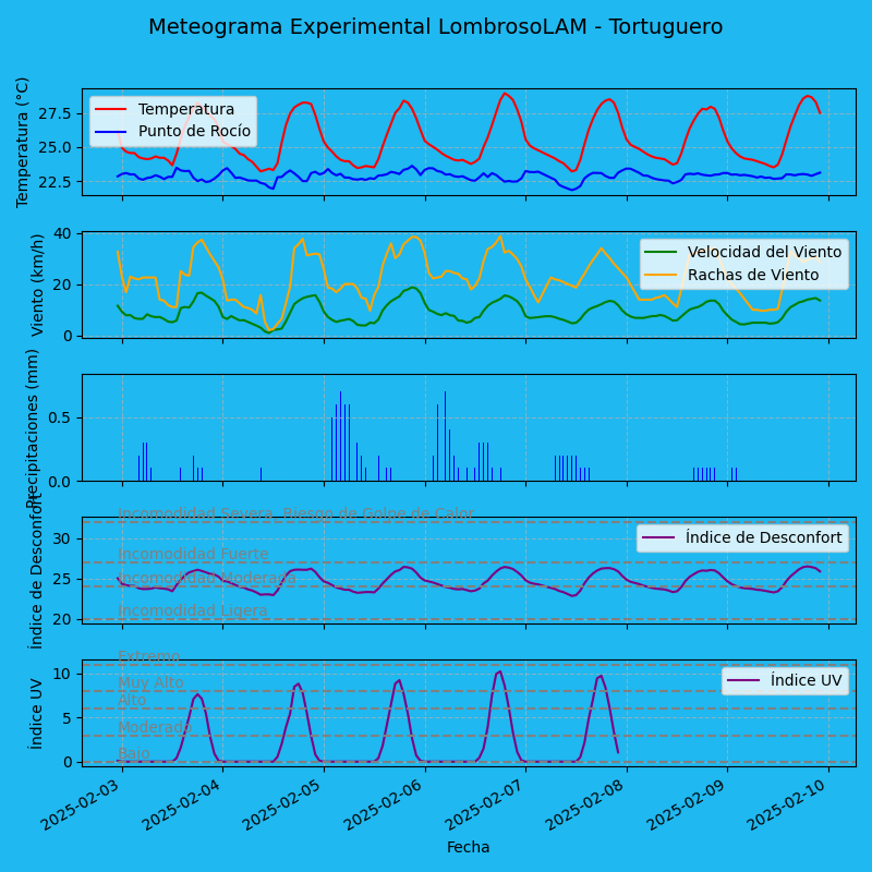
🌡️ Temperatures: Lows 23-24°C, highs 28-29°C
💨 Winds: Gusts between 30-38 km/h
🌧️ Precipitation: Some showers between February 5-7, drier trend afterward
Montezuma
🌡️ Temperatures: Lows 23-24°C, highs 30-31°C
💨 Winds: Gusts between 27-32 km/h
🌧️ Precipitation: None
Karen Mogensen Reserve
🌡️ Temperatures: Lows 20-21°C, highs 32-33°C
💨 Winds: Gusts between 25-32 km/h
🌧️ Precipitation: None
Tropical Meteorology, Climate Change & Biodiversity

The Papagayo Jet plays a vital role in marine biodiversity, but climate change may alter these dynamics. Changing rainfall patterns are also affecting forests, rivers, and habitats such as Tortuguero’s sea turtle nesting sites. Monitoring these weather conditions is crucial to understanding and mitigating climate change in one of the world’s most biodiverse countries.
📍 Luca Lombroso, Meteorologist AMPRO
Foreste per Sempre OdV & Osservatorio Geofisico di UNIMORE

